Evolution Encyclopedia Vol. 2
Chapter 19

EFFECTS OF THE FLOOD
1 - WATER POWER
Water is one of the most powerful agencies in the world. It can move, slash, and rip out massive quantities of dirt and rock. Moving water in massive quantities was the primary agent used to change the face of our world at the time of the Flood.
The carrying power of rapidly moving water is astonishing.
"The astonishing power exerted by a flood of rushing water, both scouring and in transporting material, is rarely fully appreciated even today." —*Cyril S. Fox Water, (1953) p. xiv.
Effects of a local flood in India:
"P. D. Oldham has given a brief description of the carrying power of flood streams in the Cherrapunji (Assam) region, which is subject to heavy rain. He wrote:
" ' . . the water has risen only thirteen feet above the level at which it had stood a few days previously; the rush was tremendous—huge blocks of rock measuring some feet across were rolled along with an awful crushing, almost as easily as pebbles in an ordinary stream. In one night a block of granite, which I calculated to weigh upward to 350 tons [3,175 kg], was moved for more than a hundred yards; while the current was actually turbid with pebbles of some inches in size, suspended almost like mud in the rushing stream . . '
"In that region there now is practically no soil on the Cherrapunji plateau, and it is also noticeable that water carrying much mud in suspension (and its increased density there from) carries larger stones than clear water, for equal velocities." —*Cyril S. Fox, Water, (1953) p. 70.
Fast-moving water in Utah:
"In this area the 1930 floods destroyed houses and deposited debris to a depth of several feet, including boulders of all sizes up to 20 tons [18,144 kg] in weight. Some larger boulders were moved about 1000 feet [3,048 dm] from the canyon's mouth down a 4 degree gradient. Several of these weigh from 75 to 100 tons [68,03990,718 kg] each, and two, previously mentioned ,weigh 150 to 200 tons [136,077-181,436 kg] respectively. The deep gorges freshly excavated for the full length of the flooded canyons were no less impressive than the flood depositions in the valley. cuts were made in typical canyon fill in places to a depth of 70 feet [213 dm]. Long, continuous stretches of bedrock were exposed on the bottom of the channels. The canyon fill consisted on debris brought from further upstream by running water, and of materials collected from the adjacent canyon slopes. Included were boulders ranging up to 50 feet in diameter." —*R. W. Bailey, *C. L Forsling, and *R. J. Becraft, "Floods and Accelerated Erosion in Northern Utah, " in U.S. Department of Agriculture, 196, (1934) p. 9
The power of oceanic storm and seismic waves:
"Waves, particularly storm waves and tsunamis, are the most important agents of marine erosion. Smaller waves, such as those associated with surf, may carry on attrition of material and minor amounts abrasion. But, just as a stream during a single flood may do more geologic work than it will for months or years at low-water stage, so storm waves during a short period may effect more change than ordinary waves will in months. The enormous force exerted by breaking waves is attested by recorded moments of masses weighing many thousands of pounds. Air in joints and cracks is suddenly compressed and acts as if a wedge were suddenly driven into them. Recession of the water is accompanied by a sudden expansion of air with explosive force. This driving of water into cracks exerts great mechanical stress by which insoluble rocks may greatly accelerate solution." —*W. D. Thornbury, Principles of Geomorphology, (1953), p. 49
When a rock gets in the way of the ocean:
"At Cherbourg, France, a breakwater was composed of large rocks and capped with a wall 20 feet [609 cm] high. Storm waves were hurling 7,000 pound [3,175 kg] stones over the wall and moved 65 ton [58,966 kg] concrete blocks 60 feet [182 dm] . . At Wick, Scotland, the end of the breakwater was capped by an 800-ton block [726,224 kg] of concrete that was secured to the foundation by iron rods 3.5 inches [8.89 cm] in diameter. In a great storm in 1872 the designer of the breakwater watched in amazement from a nearby cliff as both cap and foundation, weighing a total of 1350 tons [1,224,693 kg], were removed as a unit and deposited in the water that the wall was supposed to protect. He rebuilt the structure and added a larger cap weighing 2600 tons [2,358,668 kg], which was treated similarly by a storm a few years later."— *Willard Bascom, "Ocean Waves, in Scientific American, Vol. 201, August 1959, p. 80
Physical principles underlying the great power of moving water:
"Supporting the plausibility of such an event is the fact that rapidly moving water increases its sediment transporting capacity as the third or fourth power of its velocity [A. Holmes, Principles of Physical Geology (1965), p. 512]. In other words, if one increases the speed of flow ten times, moving water can carry 1,000 to 10,000 times as much sediment. Such figures make the laying down of large sedimentary deposits, during a single worldwide event, appear highly feasible." —Ariel Roth, "Some Questions about Geochronology," in Origins, Vol. 13, No. 2 (1986), pp. so-81.
2 - WHEN WATER AND MAGMA MIX
Terrific explosions have occurred earlier in history. About 1520 B.C., the Aegean volcanic Island of Thera exploded, blowing 32 square miles [51 sq kg] of the island into the air. What is left of Thera is now 1,300 feet [3,962 dm] below the level of the Mediterranean Sea. That volcanic explosion ended the Minoan civilization on Thera and nearby Crete.
A few centuries earlier, Mount Mazama, a 12,000-foot [3,658 m] mountain in southwest Oregon blow its top. Over 5,000 feet[1,524 dm] of that top disappeared as 17 cubic miles [27.3 cu km] of earth went up into the sky! Then the core collapsed, and today the deepest lake in America is the result: the 1,932-foot[5,888 dm] deep Crater Lake, surrounded by 500 to 2,000 foot [1,524-6,096 dm] high rims.
Thousands of volcanic eruptions occurred during and after the Flood, and volcanic eruptions can have powerful effects.
The Explosion at Krakatoa. There are thousands of extinct volcanoes in the world. Many of them, at the time they were blowing off, were inundated by ocean and flood wafers. What happens when water and liquid rock (magma) mix? Here is the story of what water did to one active volcano—with powerful effects upon the entire world:
For three months the people of Batavia had been intrigued by a series of minor rumblings and puffs of ash from a tiny, mountainous island in the Sunda Strait, the ocean channel between Java and Sumatra.
At 1 p.m. on the afternoon of August 26, 1883, the tiny island of Krakatoa with its small volcano began a series of explosions. (At that time it was part of the Netherlands East Indies; now it is part of Indonesia.) With increasing intensity, one explosion followed another. Within one hour after they began, a black cloud 17 miles high [27 km] loomed over the Sunda Strait. By 5 p.m., the first of a series of seismic sea waves—caused by undersea earthquakes accompanying the eruption—began lashing the coasts of Java and Sumatra. Entire villages were destroyed.
That night the deafening explosions continued unabated. "The eardrums of over half my crew have been shattered," wrote the captain of a British vessel 25 miles [40 km] from the island. Some of the explosions could be heard 2,000 miles [3,219 km] away.
Beginning that same night, W.J. Watson, captain of another British ship, the Charles Bal, carefully logged the details of the nightmare that followed. They fought their way through a rain of hot pumice stones, as choking sulfurous winds tore at their throats, and bolts of lightning flashed in the sky from an atmosphere supercharged with static electricity.
About 10 a.m. the next morning, the 27th, everything became very quiet. The sailors and their captain hoped that the worst was behind them. At two minutes past 10 it happened! Ocean water poured down a side vent hole—directly into the heart of the volcano!
What had occurred a thousand times over during the Flood, occurred again—and produced one of the biggest explosions in centuries.
The entire island of Krakatoa blew up! A column of rock and fire hurtled skyward. Up and up it went—to an estimated height of 50 miles [80 km]! In a few seconds, the bulk of the 2,600-foot (7,925 dm] mountain was no longer on earth. Now it was in the sky overhead. Because of its great height, the finer dust in that dirt and ash was to circle the globe for two years, graying and cooling it.
The sound of the blast was heard 3,000 miles [4,828 km] away, the heavy fall of volcanic ash extended as far as 900 miles [1,448 km] distant, and significant tidal flooding occurred as far away as 4,500 miles [7,242 km] from what once had been Krakatoa. The volcano had ejected 13 cubic miles (20.9 cu km] of material. Fine dust from it drifted around the world, reddening the sky. Two or three such volcanic eruptions would have darkened instead of reddening the skies of the globe.
Nine seismic waves hurtled outward, the first bringing with it a wall of water 130 feet [396 dm] high. All together, they killed 36,000 residents of coastal towns.
On the 28th, Captain T.H. Lindeman of the steamer, Gouverneur-General Loudon, sailed close to the Java coast and wrote this report:
"Everywhere the same gray and gloomy color prevailed. The villages and trees had disappeared; we could not even see any ruins, for the waves had demolished and swallowed up the inhabitants, their homes and their plantations."
"Volcanic dust blocked out the sun for a radius of 100 miles [160.9 km]. Some of it eventually sifted to earth 1,000 miles [ 1,609 km] from Krakatoa; the rest, ejected with a force that drove it into the stratosphere, dispersed over the entire planet, causing spectacular sunsets through the closing months of 1883." —*Spyridon Marinatos, "There: Key to the Riddle of Minor, " in National Geographic Magazine, May 1972, p. 715.
Rollo Russell, an eminent physicist on the staff of the British Royal Society's Krakatoa Committee, concentrated on the ash particles ejected into the atmosphere. From reports sent in from various parts of the world, he tracked the path of the ash cloud and determined that it had circled the globe in two weeks, and then had gone on to make additional complete circuits as it spread out to the north and the south, covering the entire planet!
Studies of the atmospheric dust led to the discovery that it was composed of pumice and a glass-like lava dust. Once airborne, the heavier particles such as the pumice fell to earth first, but vast quantities of the smaller dust continued to float in the stratosphere for two years, causing the sun and moon to appear bluish or green all over in the sky from an atmosphere supercharged with static electricity.
It was decades later that scientists discovered that the darkening effect of the skies worldwide was caused less by the volcanic dust, than by a chemical reaction that took place at a great altitude. Atmospheric ozone had combined with sulfur dioxide in the ash, and this caused more darkening of the sky than did the dust itself!
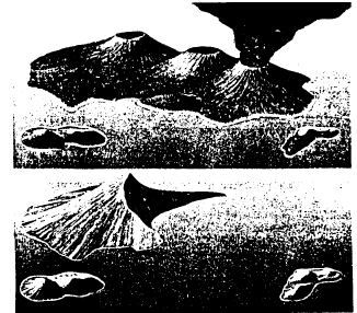
KRAKATOA
No one paid any attention to Krakatoa until it blew up in August 1883. Located in the Sunda Strait of Indonesia, it had been a small volcanic island with three cones and two smaller islands nearby. Here is a before and after view of Krakatoa.
The Day Mount St. Helens Exploded. Mount St. Helens was just an ordinary, quiescent volcano in southwestern Washington State that decided to erupt again. Even the experts said during the weeks when it began puffing that there was nothing to worry about. Then it happened: just one volcano that decided to explode.
On Sunday morning, May 18, 1980, at 8:32 a.m., Mount St. Helens went through the roof of the sky with a roar that was heard for 200 miles[322 km]. Scientists estimated that the blast was equal to the force of 500 Hiroshima-type nuclear bombs.
For 23 days prior to the explosion, a bulge on the north face of the mountain had been expanding at a rate of 5 feet [152 cm]per day. Gradually, great fracture lines appeared all over that flank. Hidden beneath it, inside the mountain was a vast cavern of hot ash and steam.
A low-level earthquake triggered the blast, by causing the north face to slide downward into the North Toutle River Valley. It was as if a gigantic door had been opened, and through its portals erupted a high velocity blast of steam and ash. Enough ash poured out to provide a ton for every inhabitant on earth! A lateral-sideways-blast shot out that devastated 240 square miles [386 sq km] of forest land to the north of the mountain. Atmospheric temperatures close to the mountain exceeded 500°C [932°F]. Thousands of animals and 61 people were killed, and millions of trees were thrown down. After tearing off the top of the mountain, the blast then aimed straight up—and continued to pour forth ash and pumice for several hours.
The explosion lowered the south wall, blew away the north wall, and produced an immense 1 x 2-mile [1.6 x 3.2 km] diameter crater in the middle.
Two scientists provide us with additional details:
"Up to 600 feet [1,828 dm] of strata were formed since 1980 at Mount St. Helens, and this from one of the smaller catastrophes in earth's history!" —Richard B. Bliss, Origins (1988), p. 60.
"The explosion of Mount St. Helens in Washington State on May 18,1980 was initiated by an earthquake and rockslide involving one half cubic mile of rock. As the summit and north slope slid off the volcano that morning, pressure was released inside the volcano where super-hot liquid water immediately flashed into steam. The northward-directed steam explosion released energy equivalent to 20 million tons [18 billion kg] of TNT which toppled 150 square miles [241 sq km] of forest in six minutes. In Spirit Lake north of the volcano, an enormous water wave initiated by one eighth cubic mile [.2 cu km] of rock slide debris stripped trees from slopes as much as 850 feet [260 m] above the pre-eruption water level. The total energy output on May 18 was equivalent to 400 million tons [362,872 million kg] of TNT, or approximately 20,000 Hiroshima-size atomic bombs." —Steven Austin, "Mount St. Helens and Catastrophism," Proceedings of the First International Conference on Creationism, Vol. 1, (1s8s).
"Up to 600 feet [1,829 dm] of strata have been formed since 1980 at Mount St. Helens, [including] fine pumice ash laminae and beds from one millimeter thick to greater than one meter thick, each representing just a few seconds to several minutes of accumulation . . Mount St Helens teaches us that the stratified layers commonly characterizing geological formations can form very rapidly by flow processes.
"The landslide—generated waves on Spirit Lake stripped the forests from the slopes adjacent to the lake and created an enormous log mat, made up of millions of prone floating trunks . . [which are] gradually sinking to the lake floor . . Many trees float in upright positions . . These trees, if buried in sediment, would appear to have been a forest which grew in place over hundreds of years, which is the standard geological interpretation for the upright petrified 'forests' at Yellowstone National Park.
"Scuba investigation of the upright deposited trunks shows that the some are already solidly buried [at the bases] by sedimentation . . The Spirit Lake upright deposited stumps, therefore, have considerable implications for interpreting 'petrified forests' in the stratigraphic record." —Steven A. Austin, "Mount St. Helens and Catastrophism, " in Impact, July 1986, pp. 1-3.
Great devastation had been produced in the surrounding area, and the volcanic cloud blew eastward across America and thence around the world.
All that from one volcanic explosion on a spring day in May.
The Tambora Eruption. Less well known was the volcanic explosion that occurred on the island of Sumbawa in 1815. But volcanists consider it to have been a more powerful explosion than that of Krakatoa in 1893.
Sumbawa is one of the hundreds of islands, large and small, that form the country of Indonesia. The island chain extends over 2800 miles [4,506 km] from west to east, and is dotted with active volcanoes along its entire length.
If you were to go there today, you would find one of the craters, Tambora, is 9,256 feet [2,821 m] high. Experts believe that, prior to that eruption, it was 9,800 feet [2,987 m] in height. All that remains today is a five mile [8 km]-wide crater.
When it blew its top in 1815, the entire upper portion of the mountain disappeared into the atmosphere. It has been estimated that over 50 cubic km [31 cu mi] of ash was ejected from the crater, 2 1/2 times as much as during the better known eruption of Krakatoa in 1883, and a hundred times as much as Mount St. Helens in 1980.
Ash fell over a huge area and, 300 miles [483 km] away, day turned into night in Java. More than 4 years later, ships at sea still reported masses of floating pumice.
So much ash and volcanic gas entered the atmosphere that a pall spread around the world, cutting down the light from the sun, and affecting the global climate.
Crops failed in both North America and Europe in 1916, and it became known as the "year without a summer." There were frosts in New England in July and August. In Wales, with the exception of only 3-4 days, rain fell all summer between May and October. (Meteorologists tell us that raindrops are formed around particles of dust, so an increase in dust can increase rainfall if dewpoint and other factors are adequate.)
A scientific conference was held in Washington D.C. in November 1983, to discuss what might happen if a nuclear war occurred. The Tambora explosion was the data base used for their analyses. From this, it was decided that a nuclear war would produce a "nuclear winter." Yet, something quite similar occurred after the Flood when hundreds of volcanoes were exploding. The result at that time was an ice age that produced glaciers in upper North America, Europe, and Asia. For hundreds of years thereafter, the world was still trying to warm up.
3 - KILLED, FROZEN, AND BURIED
Hundreds of volcanoes exploded, darkening the air throughout the entire planet. The results were dramatic:
The rapid cooling brought sudden changes of climate.
"One of the periods of wholesale destruction of life occurred at the end of the last ice age . . In a few thousand years life on earth assumed a radically new aspect... It is apparent that millions of animals once flourished in areas now bitterly cold...
"With regard to the last ice age, we have recently come into possession of new information that deepens its mystery... By use of the [radio-carbon] method, scientists revised the date of the end of the last ice age, making it only 10,000 years ago, instead of 30,000 years...
"This discovery challenged the fundamental principle of the system established by the nineteenth-century geologist, Charles Lyell. He supposed that geological processes in the past always proceeded at their present rates: processes such as rainfall, snowfall, erosion and the deposition of sediment. . . there was a very marked acceleration of the rate of these geological processes during the last part of the ice age. Some factor must, therefore, have been operating that is not operating now...
"The other new method of dating, which we call the ionium method, has also produced a major upset. Applied to date the sediments obtained in cores from the bottom of the Ross Sea in Antarctica, it has revealed that the most recent 'iceage' in the Rtes Sea began only 6,000 years ago!" —*Saturday Evening Post, January 70, 1960, p. 66. [Quoting Anthropologist C.H. Hapgood.]
Scientists are puzzled with what they find.
"About one seventh of the entire land surface of our earth, stretching in a great swath round the Arctic Ocean, is permanently frozen... the greater part of it is covered with a layer, varying in thickness from a few feet to more than 1000 feet [3,048 dm], of stuff we call muck. This is composed of an assortment of different substances, all bound together with frozen water, which becomes and acts as a rock... it is usually for the most part composed of fine sand or coarse silt, but it also includes a high proportion of earth or loam, and often also masses of bones or even whole animals in various stages of preservation or decomposition . .
"The list of animals that have been thawed out of this mess would cover several pages... The greatest riddle, however, is when, why and how did all these assorted creatures, and in such absolutely countless numbers, get killed, mashed up and frozen? . .
"These animal remains were not in deltas, swamps or estuaries, but were scattered all over the country... But last, and worst of all, many of these animals were perfectly fresh, whole and undamaged, and still either standing or at least kneeling upright...
"Here is a really shocking—to our previous way of thinking—picture. Vast herds of enormous, well-fed beasts not specifically designed for extreme cold, placidly feeding in sunny pastures, delicately plucking flowering buttercups at a temperature in which we would probably not even have needed a coat. Suddenly they were all killed without any visible sign of violence and before they could so much as swallow a last mouthful of food, and then were quick-frozen so rapidly that every cell of their bodies is perfectly preserved." —*The Saturday Evening Post, January 16, 1960, pp. 39, 82-83.
It was only a few thousand years ago that the Antarctic was ice-free.
"Carbon 14 dating has shown that Antarctica's ice is less than 6000 years old. Holmes writes that 'Algae remains, dated at 6000 B.P. (before present] have been found on the latest terminal moraines' (Principles of Physical Geology, p. 718). This shows that Antarctica must have been sufficiently free from ice for green algae to grow, 6000 years ago." —Reginald Daly, Earth's Most Challenging Mysteries (1975), p. 227.
4 - PETRIFIED WOOD
What conditions produced petrified wood? Does petrified wood prove long ages of time? Here are facts that you will want to know.
Petrified logs are not the result of a local catastrophe, but were deposited by flood waters.
"Petrified logs have been an enigma to many scientists. The evidences point rather clearly to catastropohic conditions that prevailed at the time of the Flood, when these thousands of trunks were transported and grounded in huge log jams.
"Many of the trunks appear to have the bark intact, indicating rapid burial before rotting could occur. The wood tissue is very well preserved as agate. Foliage has been stripped from the trunks. This was no local catastrophe, because these types of fossil trees from the 'Triassic' are widespread over the Southwest. No geologist insists that the 'forest' is in situ [where the trees originally grew], and it is obvious that petrified logs are not being formed anywhere in the world —John Whitcomb, World that Perished (1988), p. 110.
These include broken remnants of large trees.
"There [in the Petrified National Forest of the American Southwest] lie thousands of fossilized logs, many of them broken up into short segments, others complete and unbroken. . The average diameter of the logs is three to four feet [9-12 dm], and the length sixty to eighty feet [183244 dm]. Some logs seven feet [21 dm] in greatest diameter and 125 feet [381 dm] long have been observed. None are standing in position of growth, but, with branches stripped, lie scattered about as though floated by running water, until stranded and subsequently buried in the places where they are now found. The orignal forests may have been scores of miles distant. The cell structure and fibers have been almost perfectly preserved by molecular replacement of silica." —Raymond C. Moore, Introduction to Historical Geology (1958), pp. 401-402.
Petrification occurs when fluid containing silica compounds replaces wood cells, exactly duplicating them in the process. In the amount of time it takes for wood to rot, the replacement must be entirely completed.
"Anne C. Sigleo in a paper entitled "Organic Geochemistry of Silicified Wood, Petrified Forest National Park, Arizona" that appears in the September 1978 issue of Geochimica et Cosmochimica Acta (vol. 42, pp. 1397-1405) demonstrates that silica mineralization is an impermeation or void-filling process in which mineral matter is deposited in cracks, openings between cells, and spaces left by cell fluids. This process takes place while the wood is relatively intact. Consequently petrified wood preserves the original pattern of cell structure, and often contains carbon and organic compounds. For noncarbonaceous petrified wood the organic material was degraded and removed subsequent to mineralization. The most probable mechanism for wood silification as proposed by Dr. Sigleo is hydrogen bonding between silicic acid [SI(OH4)] and the hydroxyl functional groups in cellulose." —R.H. Brown, "How Rapidly Can Wood Petrify?" in Origins, vol. 5, no. 2 (1978), p. 113.
It has been said that petrified wood proves that the earth has been here for millions of years. But there is clear evidence that petrification of wood can take place in a relatively short period of time. (Interestingly enough, if petrification did not occur fairly rapidly, the tree would have rotted away before it could complete the petrification process, whereby silicates replace the wood cells.)
"More than a century ago, in 1867, a scientist asked how one would account for the fact that wood had turned to stone without injury to the most delicate vegetable fibers. If long periods of time passed during the process of petrification, decay would destroy much of the structure long before. [An excellent point!]
"The same problem was noted in the case of fossilized sponges. The most delicate structures are perfectly preserved in flint. Yet these same structures are destroyed usually by decomposition only a few hours after the death of the sponge. If petrification occurs at all under the right conditions, it happens very quickly.
"Counter to commonly held beliefs and popular textbooks, a scientist in 1947 noted that logs had petrified in less than one year [Henry H. Andrews, Ancient Plants (1947)].
"Several years ago, a surprising find was discovered in India. Small pieces of wood had been worked by man before they had become fossilized. [Anthropos, 1963-1964; 1969, 921-40].
"A number of cut fossil bones were discovered in various parts of Lombardy, Italy. Scientists who studied the finds determined that they had been produced by a cutting implement before they became mineralized. The fossils were dated from the Pliocene Epoch, i.e., before the age of man [Journal of the Transactions of the Victoria Institute, 13:343]." —Erich A, von Fange, "Time Upside Down," in Creation Research Society Quarterly, June 1974, p. 21.
Total mineral replacement can occur in nature within a few years.
"Silica mineralization evidently takes place within the chemical (impurity concentration) and pH (acidity-alkalinity) range of most surface waters. Dr. Sigleo cites experiments which indicate that [1 ] silica deposits at the rate of 9.1 to 4.0 millimeters [.358-.157 in] per year on wood immersed in alkaline springs at Yellowstone National Park; [2] fresh twigs will partially silicify within 24 hours at room temperature in a sodium metasilicate solution at concentrations of 5-10 parts per thousand; [3] fresh wood can be silicified within a year by alternate immersion in water and ethyl silicate. The later process does not represent naturally occurring conditions. Ethyl silicate is used because in the presence of water it decomposes and releases a high concentration of monomolecular silicific acid within the wood tissue. Also of interest, but not mentioned by Sigleo, is the observation that [4] plant tissue silicifies after several years of immersion in jars of water containing 750 parts per million of silica.
"These examples provide some possibilities regarding the formation of petrified wood and suggest that [5] wood could become petrified within a few years if it remained saturated with water that had percolated through a layer of fresh volcanic ash." —R.H. Brown, "How Rapidly Can Wood Petrify?" in Origins, vol. 5, no. 2 (1978), pp. 11 &114.
5 - THINGS TO THINK ABOUT
This chapter, along with the preceding one, contains a large amount of evidence for the Genesis Flood. Here are a few additional evidences, plus some interesting facts to think about:
HOW TO MAKE SANDSTONE QUICKLY—Evolutionists claim that it requires long ages to produce sandstone, yet there is evidence that it can be made quite rapidly.
"Norwegian geologists examining a barbed wire sandstone in Jaren (near Stavanger, Norway) have discovered that petrification can occur very rapidly, geologically speaking. During World War II the Germans, fearing an invasion from England across the North Sea, built a complex defense system along the coast of southwestern Norway. The German occupation forces placed tons of barbed wire on some of the long beaches which extended nearly uninterrupted from Sola to Ogna as part of the defenses.
"After the war, most of the barbed wire was removed. However some of it was covered with wind-blown sand. After winter storms in 1981, some of the buried wire was uncovered on the shore of Hellestrio in the municipality of Sola after about 40 years of burial. The buried wire had been transformed into lumps of sandstone sediment.
"While sandstones which occur naturally in the mountain areas of Jaren are heavily deformed and are [supposedly] dated up to 800 million years (Precambrian), this sandstone is of far younger age and can be dated accurately. From scientific literature it is known that similar sandstones are formed when iron corrodes. The chemical reaction starts when iron which is buried in sand begins to corrode. It seems that Fe02 combines with COZ and CaC03 to form a hard crystalline substance that is precipitated between grains of sand.. A third ingredient needed, of course, is either salt or fresh water to start the process." —Olav Wik, "Barbed Wire Placed in World War II Already Petrified, " in Creation Research Society Quarterly, June 1987, p. 14.
WHERE DID THE SAND COME FROM—Analytic studies of desert sand reveals that it was laid down by a major flood.
"It is often taken for granted that grains of wind-blown sand, such as that found in a desert, should be more rounded than those on a beach. But a study, a few years ago, in the Simpson Desert, Australia, showed that the grains there were quite angular.
" . . While such deposits as loess, or the sand which went to form sandstone, are often supposed to have been deposited by the wind, the Flood would seem to have been a very likely agent. The study cited here would seem to show that it is hard to decide one way or the other by the shape of the grains..
"There is another possible clue, however, which seems to have been little noticed. One might expect wind-blown sand often to contain vegetable material, such as tumbleweed, bits of brushwood, etc. Such debris is common in many sand dunes. And if the sand remained or hardened, the debris would remain as fossils.
"When the sand was deposited by water, on the other hand, such debris would be floated away. As far as I can learn, fossilized debris is not common in sandstone. So this may be evidence that the sand was deposited by water, and what better opportunity has there been for such deposition than during the Flood?" —Harold L. Armstrong, "On the Nature of the Grains of Windblown Sand, " in Creation Research Society Quarterly, June 1985, p. 47.
THE EARTH HASN'T DRIED OUT YET—There is clear evidence in the soil beneath our feet that the earth is closer to the water-soaked condition it incurred at the time of the Flood. In addition, the evidence indicates that Flood occurred not more than a few thousand years ago.
"Did you know that the earth beneath you is something like a sponge filled with water? It is for the reason that it was laid down during a gigantic deluge and, because that Flood occurred not far in the past, the ground has been able to maintain that water content.
"Alviso, California back in the 20's and early 30's, was a small community on the southern shore of San Francisco Bay. Its altitude was originally just above sea level, but in the 30's had already sunk four feet [122 cm]. Now the area is 6 feet [183 cm] or so below sea level and only stays dry because of levees that have been built. Those levees were broken in March '83 and the area was flooded.
"A March '83 Smithsonian article on aquifers stated, 'The crust of the earth is porous like a sponge. It's just all filled with water.' However, in our area, ff the water table level becomes lower than around 125 ft. [381 dm], the weight of the dry sedimentary rock 'sponge' causes a gradual collapse of the ground, or shall we say, of the 'sponge.' And once it has collapsed, it will not expand again and it will not hold as much water as ft used to even if it were pumped in.
"Because the 'sponge' collapses when the water table drops below a certain level, that means that the 'sponge' has never been dry before or it would not collapse now. Because the 'sponge' is sedimentary [fossil-bearing] rock, that means it was formed, or I should say solidified, under water. The only event that could produce the great depth of sediments is a world-wide flood.
"There are those who say that they do not see any scientific data that support the idea of a world-wide flood. For me, the very existence of 50 million or more cubic miles [80 million km] of sedimentary rock is proof. But now I also believe the subsidence of many areas due to removal of ground water is further proof that Noah's Flood was a historical event. " —Everett H. Peterson, "Evidence for a World-wide Flood?" in Creation Research Society Quarterly, December 1983, p. 189.
TROPICAL PLANTS IN ANCIENT TIMES—Tropical plants used to grow all over the world; this is the surprising conclusion of a variety of fossil botanical studies.
"Extensive catalogues or `floras' of fossil plants have been produced at many localities throughout the American West and elsewhere. The results of these studies have been summarized in several volumes of which the following are representative: Andrews (1947), Andrews (1961), Arnold (1947), Darrah (1960), and Taggert and Cross (1980).
"From these the fact emerges that there are distinct differences between the species found in the fossil strata and the plants living at those same sites today. Near Clarkia, Idaho, for example, there are abundant fossils of subtropical plants where today only conifer forests flourish [T. Clutter, "The Clarkia Fossil Bowl," in American Forests, 91(2):22-25]. In the Green River fossil flora of southwestern Wyoming there are fossil palm leaves in situations which now support only sagebrush, grassland, and dwarf conifer life forms (H.H. Andrews, Ancient Plants and the World They Lived In (1947), p. 203]. The Kenai fossil flora of Alaska contains such subtropical species as the magnolia and fig [W.C. Darrah,
Principles of Paleohotany (1960), p. 231 ]. Fossil floras labeled Eocene from Oregon and California appear to contain tropical plant species which are very much unlike the forms currently growing in those areas. In regions of the western United States that presently support grassland, chaparral shrub, or desert vegetation, there are numberous fossil beds containing temperate, subtropical and even tropical plants." —George F. Howe, "Mountain Moderated Life: A Fossil Interpretation," in Creation Research Society Quarterly, June 1987, p. 9.
RECENT CHANGES IN MOUNTAINS ANDIOR CLIMATE—There is evidence that either mountains and/or climate have radically changed in the recent past.
"It has been shown that within today's observed atmospheric circulations, mountains act as barriers producing rain shadow effects on the lee side. These shadow effects are recognized by others to be sufficient to have originated and now to maintain more arid climates than [existed in those areas in the past]. Therefore, there appears to have been a time when the mountains or the earth's climate, or both, were vastly different than today. . [Thus] mountains may have been relatively recent additions." —Kenneth A. Nash, "Mountains and Lakeside Climate: An Indicator of Change, " in Creation Research Society Quarterly, June 1987, pp. 13-14.
HOW TO PUSH UP A MOUNTAIN—One researcher, *James, has shown that, if a major flood earlier occurred, and if the ground was broken up enough in the process,—enough steam would have been generated to easily raise our present mountains.
"Douglas James supposed that in ancient times a cubic mile or so of water somehow entered the interior of the earth and as it came into contact with some 250 million cubic miles [402 million cu km] of molten material, produced a gigantic subterranean steam generator. He assumes that the water expanded its volume by a factor of 1,670. The escaping steam would have had many effects and would have gone a long way, James holds, to synthesize mountains at a greater speed than any ice age could produce them.' . . Westberg, like James, believes that 'there is no force equal to steam to raise mountains.' . . Westberg believes that some of the mountain-building earthquakes were actually caused by Flood waters lubricating vast underground regions, like spill waters which run back into mines may generate earthquakes today." —George F. Howe, "Mountain Moderated Life: A Fossil Interpretation," in Creation Research Society Quarterly, June 1987, p. 11.
ADAPTING TO A NEW DIET—The Chinese bear, the panda, is a large bear with all the equipment needed for flesh-eating, and yet it almost entirely eats only a vegetarian diet. On that basis, back in the beginning tigers and lions could have looked much as they do today.
The panda in China is a powerfully-built animal, with strong jaws and large teeth; yet its diet is almost entirely herbivorous. Creatures which are now carnivorous could, originally at creation have been similar in appearance, while only eating plants.
"Equipped with powerful jaws and long molar typical of carnivores, the panda eats enormous quantities of fibrous bamboo shoots, although occasionally it hunts small mammals to complete its diet." —*F.B. Salvadoriand *P.L. Florio, Rare and Beautiful Animals (1978), p. 62.
HOW TO MAKE NEW "OLD LAND" QUICKLY— Here is but another indication that our world is not as old as it appears. Within a few short years after it came into existence, the island of Surtsey in the North Atlantic had the appearance of having been there for thousands of years.
On November 14, 1963, at 7:15 a.m., crewmen aboard a fishing vessel 20 miles south of Iceland saw black smoke billowing out of the sea. That evening a ridge of hardened lava was to be seen just beneath the surface of the sea. By the next morning a new island had been born. Eruptions stopped 3 1/2 years later, but even by the next year Surtsey was looking quite mature:
"Only a few months have sufficed for a landscape to be created which is so varied and mature that it is almost beyond belief . . Here we see wide sandy beaches and precipitous crags lashed by breakers of the sea. There are gravel banks and lagoons, impressive cliffs resembling the White Cliffs on the English Channel. There are hollows, glens, and soft undulating land. There are fractures and faulted cliffs, channels and rock debris. There are boulders worn by the suit, some of which are almost round, and further out there is a sandy beach where you can wade at low tide without getting wet.
"An Icelander who has studied geology and geomorphology at foreign universities is later taught by experience in his own homeland that the time scale he had been trained to attach to geological developments is misleading.. What elsewhere may [in theory] take thousands of years may [in fact] be accomplished here in one century. All the same he is amazed whenever he goes to Surtsey, because there the same developments may take a few weeks or even a few days. " —*Sigurdur, Thorarinsson, Surtsey (1964).
SEEDS PRESERVED IN SALT WATER—Seeds can routinely sprout after long periods of dormancy in salt water. That fact helps explain the new growth of vegetation after the Flood.
"In a recent UPI release [Sunken Ship's Seeds Sprout 350 Years Later, United Press International release, June 22, 1987], it was reported that seeds soaked for 350 years in salt water muck have successfully germinated. The seeds were recovered recently off Key West, Florida, from the sunken Spanish treasure ship, Mocha, which was known to have gone down in 1622. The ship contained seeds of grape, olive, apricot, and beggar tick (Bidens albs), the last of which germinated to yield two-inch beggar tick seedlings at the time of the report." —News note, in Creation Research Society Quarterly, December 1987, p. 144.
AMERICAN DINOSAURS AND ELEPHANTS—We are closer to our past than you might imagine. It appears that the mammoth and the mastodon, both large elephants, lived for a time after the Flood. Their remains are to be found in ice remaining from the ice age. But did they all perish back then? The Flood did not occur so very long ago; 4,300 years is not a long time.
"The mastodon arrived in America during the Miocene epoch, according to authors of texts, multiplied astonishingly, and then for no known reason became extinct. Various dates, e.g. 4500 B.C., are given when the last elephant in America died . .
"In 1929 the skeleton of a mastodon was found in Ecuador. Evidently killed by Indians, a circle of fires had been built around the body for convenient roasting of the flesh. A landslide covered the site, which also included broken painted pottery and artifacts. This remarkable find was dated at the beginning of the Christian era.
"In 1928 a Mayan worship was uncovered in Central America. The archeologist concluded that the owner of the shop, dated from the second to the fourth century A.D., must have kept a mastodon, for the bones of the animal were found among smashed bowls and jars.
"One paleontologist believed that mammoths still lived in the interior of the American continent at the time of the first Spanish explorers. He supported his belief by the fact that such bones are found under a few inches of peat. Many accurate descriptions of the elephant have been collected from various Indian tribes in America and Canada.
"David Ingram, an English adventurer, was put ashore with 113 other men between Mexico and Florida in 1568 and wandered for years in the American interior before making his way to the east coast of the American colonies. In his report to the state secretary of Queen Elizabeth, he described precisely and drew accurate pictures of elephants as well as bison and other animals they had observed during the journey.
"This account was not taken seriously, but it is a curious fact that 200 years later President Jefferson was informed by a delegation of Indian chiefs that the hunting in the interior lands included animals described as elephants. It is a matter of record that President Jefferson asked Lewis and Clark to be on the alert for elephant herds during their exploration of the West." —Erich A. von Fange, "Time Upside Down," in Creation Research Society Quarterly, June 1974, p. 21.
HOW TO MAKE A CAVE—How long does take for a cave to form? Actually, far less time is required than might otherwise be supposed. Both limestone deposition and radiocarbon dating surveys indicate that many caves were made within the past few thousand years:
"As the Flood waters began to recede off the earth, it is postulated that they would contain humic acid and Co2 from the decomposition of living organisms. This solution would attack recently-consolidated jointed limestone causing cave formation in many areas. Immediately after the formation of limestone, water could seep through the joints enlarging conduits and forming larger passages . .
"As receding Flood water went through an ever-increasing opening in limestone the velocity of the water would have had an effect . .
"It is felt that the deposition of limestone, cave formation and subsequent precipitation of dripstone [stalactites] occurred rapidly in recent time. There is evidence to support such a claim.
"In radiocarbon dating of calcite deposits in a cave, it was found that the material had an excessively high radiocarbon content [W.S. Broecker, et. al., "Radiocarbon Measurements and Annual Rings in Cave Formations, " in Nature 185(4706):93-94]. Considering the standard interpretation, C02 from decaying soil vegetation rich in radiocarbon combines with H20 and CaC03 from limestone (supposedly free of radiocarbon) to produce bicarbonate ions.
"If this material precipitated in a cave it would be expected that the radiocarbon content of a stalactite would be 50 percent of that of the decaying vegetation [G.W. Moore, "The Growth of Stalactites," in National Speleological Society Bulletin, 21(Pt. 2):101 (1962)]. The stalactites tested contained about 90 percent of the radiocarbon content of modern vegetation! One possible interpretation is that the limestone is not very old, and it still has radiocarbon in it." —Emmett L. Williams and Richard J. Herdklotz, "Solution and Deposition of Calcium Carbonate in a Laboratory Situation II," Creation Research Society Quarterly, March 1977, pp. 197-198.
EVIDENCE THAT THE ICE AGE WAS RECENT—How long ago was the ice age? It is generally thought to have occurred 15,000 years ago—which is not far back. But radiocarbon dating indicates that it took place only a few thousand years ago, and ended within the past 2,000 years:
"By this time tens of thousands of C-14 dates have been published from tests performed in various laboratories around the world. In the annual volumes in which the dates are published, concern has been expressed about many relatively young datings which violate established geological age notions. One example given was ice age materials that were dated within the Christian era by C-14 methods . .
"United States Geological Survey scientists carried out studies which gave a G14 date as recent as 3300 years ago, but no textbook author treats such a puzzling find which falls well within historic times [Immanuel Velikovsky, Earth in Upheaval (1955), pp.158-159; CRSQ 5(2):67]." —Erich A. von Fangs, "Time Upside Down, " in Creation Research Society Quarterly, June 1974, pp. 17-18.
THE EFFECT OF TIDAL WAVES—During the high-point of the Flood, everything would be covered, and lunar-caused wave action could for a time achieve a surprisingly fast speed. The following excellent analysis of the effects of tidal waves is rather startling, for it could help explain some of the factors we note in stratigraphy, bunched up fossilized plant and animal remains, etc. We are here speaking of true "tides"—tidal waves caused by lunar gravity,—not seismic waves (tsunamis) caused by earthquake shock:
"We now come to the phenomenon which may prove to be the most significant of the Flood-related agents of erosion and deposition. At the outset, let us recognize that present-day tides are mild and relatively unspectacular as an erosional and depositional agent. However, today's tides are trapped, between continental masses, producing unusual and restrictive influences on tidal movements, whereas during the Flood, tidal movements would have been unhindered, for the most part, by continental masses . .
"This brings us to the wave form called (correctly, this time!) tidal waves—especially as related to the shallow-water effects generated by global tides . .
"If the earth were totally inundated, water would exist as two huge bulges on the earth, and as the earth rotated once completely in 24 hours, a point on the earth would pass through these two bulges of water . .
"Since the circumference of the earth is approximately 24,900 miles [40,072 km] and the full rotation time for a given particle to intersect the same high water bulge twice is 24.833 hours [because the moon takes 24 hours and 50 minutes to circle the earth], then the velocity of the crest of the tidal bulge over a given point on the earth is nearly 1,003 miles per hour [1,614 km]. In terms of wave period and wavelength, the wave period, from crest to crest, would be 12 hours 25 minutes (44,700 seconds) and the wavelength would be approximately 12,450 miles [20,035 km]. In theory, this would be true if the oceans averaged 14 miles [22.5 km] in depth. However, with an average depth of only two miles, the speed of the tidal crests in an inundated world would be between 800 to 1,000 miles [1,2871,609 km] per hour, with shorter wavelengths and periods . .
"[Effects would include:] 5) Swift and powerful laterial tidal currents, perhaps covering areas of hundreds of miles across, would be generated by the unusual vertical tidal movements and aided by the Coriolis effect. Such currents could scour, sort and evenly redeposit entire regions over short periods of time, being the most important of the depositional agents of tidal faces.
"6) Tidal forces probably would not be able to match other forces (tsunamis [seismic waves], storm surges, earthquakes, volcanism) in their destructive and erosional capabilities, but tidal phenomena would be the primary agents for carrying vast amounts of sediments and causing deposits of great uniformity covering hundreds of thousands of square miles. Much of the sediments carried by tidal currents would be derived from tsunami activity. No other depositional agent can adequately explain large formations.
"7) The cyclical effects of the passage of two bulges of water each day, with all of the above phenomena occurring each time, would give rise to cyclical bedding . .
"9) The sheer weight of the bulges of water in the amplified tides of the Flood would cause isostatic adjustments, which in turn would trigger earthquakes, causing additional tsunamis.
"10) With such extreme oceanic movements, and with the mixing of changing and totally different underwater zones, chemical precipitation of limestones, dolostones and even many of the so-called evaporites could have occurred due to rapidly changing temperatures, pH and chemical concentrations, particularly in volcanic areas. It is interesting to note that some chemically precipitated limestone has been observed not to differ in crystalline structure from biogenetically produced limestone:
"11) All of the above effects would have their most dramatic results in the shallow waters of continental regions, with only small, incidental effects in deeper oceanic regions. Thus sedimentation on continents (and erosion) would occur at several times the order of magnitude as in deeper waters. This fits current observations of continental and oceanic deposits.
"12) These effects would be at their height primarily during the deepest part of the Flood. The emergence of land masses would quickly diminish the above listed results, particularly when enough land arose to disrupt the tidal wavelengths." —David B. D’Armond, "Thornton Quarry Deposits, et al.," in Creation Research Society Quarterly, September 1980, pp. 98-103.
WHITTLING ON FRESH DINOSAUR BONES—The dinosaur is reputed to have lived only during the Mesozoic Era, which is dated at 225 million to 70 million years ago. Man is thought to have first appeared a little over a million years ago. Here is a report of people having whittling on dinosaur bones—and bones have to be fairly fresh for such an activity. In addition, the bones were found in a Jurassic stratum, which would be 134189 million years before man was supposed to have existed! (Additional data on men living contemporaneously with dinosaurs (and even trilobites!) will be found in the second half of chapter 18, Ancient Man.)
"(Report was made] of two saurian [dinosaur] bones distinctly scored at regular intervals by cuts, such as might be produced by a flint knife. If the bones had been of a modern species along with implements, there would be no question but what they were of human workmanship. The bones were from a Jurassic deposit, however, so the evidence was not acceptable [Journal of the Transactions of the Victoria Institute, 23:211213]." —Erich A. von Fange, "Time Upside Down," in Creation Research Society Quarterly, June 1974, p. 21.
VOLCANIC DUST IN THE ANTARCTIC—Earlier in this chapter we mentioned that dust in the atmosphere from volcanic emissions probably caused the ice age which continued on for a time after the Genesis Flood ended. Dust from those eruptions has recently been found in the Antarctic glacier fields.
"Drilling through the ice in the Antarctic regions has revealed, at certain depths, considerable volcanic ash and dust embedded in the ice [ "Eruptions and Climate: Proof from an Icy Pudding," in New Scientist 53(783):367 (1972)]. The deposit of especial interest was estimated to be about 18,000 years old; but there is a tendency to exaggerate such ages." —Harold Armstrong, "Comments on Scientific News," in Creation Research Society Quarterly, September 1972, p. 134.
QUARTZ AND SANDSTONE MADE RAPIDLY—Evidence keeps surfacing that most of the inorganic materials we find on and in the earth could have been made within historical times.
"The Popular Science News contained a report of a find of quartz crystals in a Nevada mine which could have been formed only in a maximum of 15 years. In the same area a mill had been torn down and the discovery was made that sandstone had formed during a period of 12 years. A piece of wood with a nail in the wood was found in the sandstone. " —Erich A. von Fange, "Time Upside Down," in Creation Research Society Quarterly, June 1974, p. 21-22.
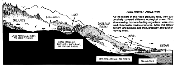
CLARK EXPLAINS "ECOLOGICAL ZONATION"—Harold W. Clark pioneered in working out the "ecological zonation" theory. According to it, there would be a tendency for those life forms living at the lowest levels to be the first to be covered with sedimentary strata by the waters of the Flood. Gradually, higher levels would then be covered. Flying creatures and the fastest land animals would tend to be buried at the highest levels. Because of the immense sloshing action of the water, some lightweight creatures found at the lowest level (such as small seashells) would also be found at higher level. Later mountain-building action would raise certain areas and confuse the basic ecological zonation pattern somewhat, but it would still be there. The result is the fossil arrangement we find in the sedimentary strata. Here is how Clark himself described it. You will want to read the entire 4-page article:
"Wherever studies have been made, the present world of life has been arranged in life zones. Each zone has a characteristic assemblage of species fitted to the environment.
"As the waters [of the Flood] rose higher and higher, and the turmoil caused waves to break against the land, zone after zone would be washed away and spread out in the surging waters. Eventually these would result in a sequence of deposits with plants and animals in the same order in which they had been on the land. Of course, one cannot expect perfect coordination between the fossil zones and the original land zones, as there would be some mixing. But the fact that there is any zoning at all indicates that there must have been zoning on the land, unless one ascribes it to geological ages.
"Sometimes the question arises: Why would not land plants appear in the Cambrian even, if the sediments were produced by Flood waters? But the picture here suggested for the rising Flood waters, comparatively little vegetation would be carried into the seas until the disturbances reached a certain volume. Any plant remains that were carried into the seas would float on the top, and would not be found in the bottom sediments‑not until the violence of the storm had increased to tear away masses of the land and bury plants and animals beneath them.
"What about the repetition of certain fossil layers? In some cases there is an alternation over and over again. In the Paris and London basins are six cycles, marine sediments having come from the north and terrestrial from the south. In Burma are alternating beds varying in thickness from 1,000 to 12,000 feet [305‑3,658 m], but all appear to have been deposited in water not over 600 feet [1,828 dm] deep. Coal beds show many alternations with shales [hardened clay], sometimes as many as a hundred such alternations being seen .
"As one considers what is described and evidence in other parts of the earth, it becomes evident that terrific back‑and‑forth washing or wave action was involved. This would account for the alternation of strata .
"But, it is asked, would not violent Flood waters carry some species completely outside their original habitats? That is true; but it would be true also that they would be most abundant in the original habitats . .
"The 'geological column' [of fossil strata] represents the spatial arrangement of the ecological zones of the world before destruction of the arrangement by the Flood.
"The ecological order cannot be worked in minute detail, because on the Flood theory allowance must be made for irregularity on account of wave action and distortion of the strata during the Flood and afterwards. But, allowing for certain irregularities such as have been noted, the ecological zonation theory does afford an alternative to the geological ages theory."‑Harold W. Clark, "Fossil Zones, " in Creation Research So‑
"How could the Flood, some ask, arrange the fossils in any order? Would it not mix them all up
Society Quarterly, September 1977, pp. 89-90.
You have just completed
APPENDIX 19-A